
Tag Cartography
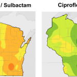
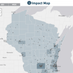
Antibiotic resistance across Wisconsin revealed by new maps
Researchers drew inspiration from easy-to-read weather maps and consulted with doctors to provide guidance at a glance of the likelihood a pathogen will respond to a particular drug in different parts of the state.

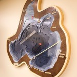
Forecasting antibiotic resistance with a ‘weather map’ of local data
To help physicians choose the best antibiotic first, researchers in the School of Pharmacy and the State Cartographer's Office are drawing inspiration from the weather.
State cartographer’s office releases third edition of statewide parcel map
The state cartographer’s office at UW–Madison has released the latest update to a portal that pulls together 72 county databases that document who owns which parcels of land in Wisconsin.
UW-Madison geoscientist offers free geologic exploration app
Rockd serves both amateur rock lovers and professional geologists, says Shanan Peters. "People see rocks at highway cuts, and some may wonder what they are and when they formed. The answers ... exist in the databases that we tap into."
UW-Madison spinoff is big-time producer of specialty maps
If paper maps are dead, nobody has read the obituary to David Knipfer, owner and operator of Mapping Specialists, a 15-person business in Fitchburg that runs the gamut from paper to digital.
Lake Mendota mapmaker shows depth of her appreciation
Caroline Rose remembers the first time she saw Lake Mendota. The Minnesota native had been accepted at UW–Madison and came to campus for a visit.
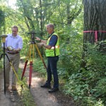
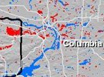
Cartography Lab partners with state on economic impact map
Students at the University of Wisconsin–Madison have played a crucial role in developing an online interactive map that shows the economic impact of investments in counties and legislative districts throughout the state.
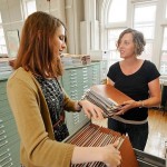
Charting a map library’s transition to the digital age
In stories, maps lead to treasure. But in real life, maps are the treasure. They reveal history, showing us how we once viewed our world, and help us understand the world as it exists now. And sometimes they hold mysteries of their own.
New campus map combines cartography know-how, best of web
One of the most frequently used campus online tools, UW–Madison’s campus map, recently received a facelift at http://map.wisc.edu.
UW exposition examines high-tech mapping
The UW–Madison campus will bring together experts from around Wisconsin on Wednesday, Nov. 16 to show off the latest in technologies and projects that utilize high-tech mapping tools called geographic information systems (GIS).
Birdseye view of Wisconsin’s past wins governor’s award
A popular website that draws from tens of thousands of rare aerial photographs of Wisconsin will receive the 2011 Governor’s Award for Archival Innovation from the Wisconsin Historical Records Advisory Board.
Recent sightings: Wisconsin flooding
View a map showing all of southern Wisconsin WisconsinView developed this map — a June 15 snapshot of the severe flooding…

Geography students put local foods on the map
As temperatures warm, farm fields begin to green and outdoor farmers' markets get under way, the time is ripe for thinking about local foods. For Madison residents, finding locally produced foods is now just a mouse click away.
Lakeshore preserve Web site wins ‘Best of 2007’ award
The interactive Web site for the University of Wisconsin–Madison Lakeshore Nature Preserve has garnered another national award.
Exhibit traces 300 years of Wisconsin and Great Lakes maps
Original maps of Wisconsin and the Great Lakes region from 17th-century drawings concocted from travelers' accounts to 21st-century images captured by satellites are on display through June 29 in the Department of Special Collections in Memorial Library at the University of Wisconsin–Madison.
Online lakeshore map wins national award
An online, interactive Web site that helps decipher the Lakeshore Nature Preserve has won an award that puts the University of Wisconsin–Madison student-driven project at the forefront of map design in the United States.