
Recent Sightings Recent sightings: Wisconsin flooding
View a map showing all of southern Wisconsin
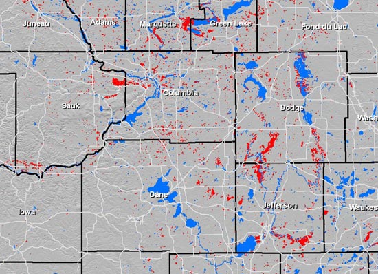
WisconsinView developed this map — a June 15 snapshot of the severe flooding that hit southern Wisconsin — for Wisconsin Emergency Management, a state agency involved in response and recovery efforts. The blue areas indicate existing lakes and rivers; the red areas indicate areas of probable flooding as measured by satellite imagery collected by the Canadian Space Agency.
WisconsinView is a federally funded UW–Madison program that offers a free Web service for easy access to a variety of statewide images and data. Read more about WisconsinView.
-
Interwoven
How Indigenous knowledge and science can work together to communicate about climate.
-
UW–Madison’s reach throughout Wisconsin adds up to $38.9 billion a year
The university supports more than 287,000 jobs and helps drive private-sector growth.
-
‘Being part of something bigger than you’ with Badger Volunteers
UW–Madison students head into the local community to find purpose and make a difference.
-
UW–Madison’s Tech Exploration Lab: Where the classroom meets the real world
The lab is built around a simple expectation: Students come to build, test and refine projects with real problems in mind.


