When the isthmus is an island: Madison’s hottest, and coldest, spots
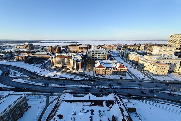
Chilly winters may temporarily mask its effect, but the downtown Madison isthmus creates an urban heat island. According to a new study, the city’s infrastructure leads to higher temperatures than its nonurban surroundings.
As Dane County begins the long slide into winter and the days become frostier this fall, three spots stake their claim as the chilliest in the area.
One is a cornfield in a broad valley and two are wetlands. In contrast, the isthmus makes an island — an urban heat island.
In a new study published this month in the Journal of Applied Meteorology and Climatology, University of Wisconsin–Madison researchers highlight the urban heat island effect in Madison: The city’s concentrated asphalt, brick and concrete lead to higher temperatures than its nonurban surroundings.
After collecting and analyzing more than two years of temperature and humidity data from a network of 151 sensors throughout the Madison region, they have found some of the area’s hottest, and coldest, spots.
The study was aimed at helping the Madison region plan for the future, to think about the impacts of the structures and local environments it creates. As more people across the globe choose to live in cities and as existing cities expand and grow — particularly the small and midsize ones like Madison — understanding how development impacts people and the environment is crucial.

Jason Schatz
While warmer temperatures may sound nice this time of year, just months ago, that same heat may have been far less welcome. Combined with climate change, hotter cities impact the health, quality of life, and environment for all that live within them.
“Cities tend to be warmer than their rural surroundings; they retain more heat,” says Jason Schatz, a graduate student in the Nelson Institute for Environmental Studies and affiliate of the Water Sustainability and Climate (WSC) project, who co-authored the study with WSC lead investigator, Chris Kucharik.
The take-home message: Local climates matter.

Chris Kucharik
“Cities have experienced their own warming,” says Kucharik, also a UW–Madison associate professor in the Department of Agronomy in the College of Agricultural and Life Sciences and with the Nelson Institute. “It’s not a magnitude of change that can be easily dismissed.”
The study is one of only a few to examine a city with fewer than 500,000 people and it created one of the most extensive climate sensor networks to date, the researchers say. Other cities may generate their own useful data with the methods they developed.
Additionally, because of the robustness of their data, the researchers were able to create a statistical tool to examine the relationship between air temperature and land cover. That data was freely available through the U.S. National Land Cover Database. Any city that can measure its air temperature can use the method.
In March 2012, Schatz worked with Dane County officials, local city governments, UW–Madison, Alliant Energy, and Madison Gas and Electric to install a network of sensors on utility poles throughout the region. The sensors collected data every 15 minutes.
“Cities have experienced their own warming. It’s not a magnitude of change that can be easily dismissed.”
Chris Kucharik
Analyzing tens of thousands of data points, Schatz and Kucharik found the urban heat island effect peaked in summer, when downtown Madison averaged 7 degrees Fahrenheit warmer at night and 3 degrees warmer during the day when compared to rural Dane County.
In winter, the effect was smaller but snow cover played a role in an average 2 degree temperature difference between urban and rural areas. During the day, the percent of the area covered by snow had a strong impact, while at night, the depth of that snow cover was most important.
The study is one of the first to examine the relationship between snow cover and the urban heat island effect.
Cities are typically warmer than rural and suburban areas. Schatz and Kucharik suspect that increased vegetation in the region’s rural areas accounts for the greater difference in temperature during the summer. Indeed, they found the magnitude of the urban heat island effect decreased toward the start of the fall harvest season, when vegetation is removed from farm fields, leaves fall from trees, and plants become less active.
“Land-use discussions here are fundamental. There is a lot Madison will have to decide in the coming decades.”
Jason Schatz
The Madison region’s coldest spots are likely that way because of the abundant vegetation they contain, their openness and their lower elevation. Cooler air tends to settle in low-lying areas, a phenomenon known as katabatic drainage.
As Madison and other cities contemplate future growth and development, the impact of the urban island effect should be part of the conversation, Schatz and Kucharik say, with the goal of making cities more livable and more resilient.
“Land-use discussions here are fundamental,” says Schatz. “There is a lot Madison will have to decide in the coming decades.”
The study was funded by the Water Sustainability and Climate Program of the National Science Foundation and a University of Wisconsin–Madison University Fellowship.
-
UW–Madison again named a ‘new Ivy’ by Forbes
The university was selected as one of the best in the country at "preparing and graduating the talent" that meets today's workforce needs.
-
UW–Madison graduate programs ranked among the nation’s best by U.S. News
Nearly 20 programs ranked in their respective Top 10 lists, shining a light on the breadth and depth of the university’s graduate offerings.
-
UW–Madison students ‘step into the professional world with a purpose’
More than 90% of UW graduates say their education prepared them for their career, according to new survey results.
-
How UW–Madison and industry are working together to shape Wisconsin’s AI future
As businesses explore how to apply AI effectively and responsibly, UW researchers, faculty and students are offering their knowledge in the emerging space.