
Bringing together Earth and sky imagery
Integrating studies of the Earth with those of the atmosphere and beyond, the Environmental Remote Sensing Center (ERSC) recently joined the Space Science and Engineering Center (SSEC) in the University of Wisconsin–Madison Graduate School.
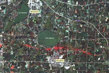
Change detection techniques can help map damage areas following severe weather. This image shows, from left to right, the ground trace of an F3 tornado that touched down August 18, 2005 on the north side of Stoughton, Wisconsin. Researchers at the Environmental Remote Sensing Center at the University of Wisconsin–Madison produced this image for the Wisconsin Emergency Management using the blue and green spectral bands of a Landsat 5 TM image acquired one month before the storm and the red band of a Terra ASTER image acquired 10 days after the storm.
Photo: courtesy UW–Madison Environmental Remote Sensing Center; image processing by Peter Wolter; cartography by Sam Batzli.
Environmental remote sensing is a science that utilizes data and imagery of the Earth’s land and water collected from satellites and aircraft, along with field measurements to monitor and map environmental systems. ERSC uses these technologies to explore the Earth in various ways, including: mapping tornado damage tracks; monitoring algal blooms in lakes; mapping wetlands; quantifying urban sprawl; assessing agricultural land use; and supporting environmental management, transportation planning, and emergency management.
Supported by NASA, the latest ERSC initiative involves studying and monitoring water levels and biophysical conditions in large lakes around the world with data from a variety of satellite-based instruments.
In addition to research activities, ERSC also engages the public through education and outreach programs. Among these efforts are “WisconsinView,” a remote sensing data distribution and education consortium funded by the U.S. Geological Survey; and the “MapTEACH” geospatial education and outreach project in Alaska, funded through a collaborative grant from the National Science Foundation.

Chlorophyll, whether in terrestrial plants or in floating algae in lakes, has a distinct spectral signature that can be measured by satellite. This image, produced using a multi-date composite of several Landsat scenes, shows algal blooms on lakes Mendota (top) and Monona (bottom right) in Madison, Wisc., Oct. 31, 1999. The algae blooms appear bright green due to their particular timing.
Photo: courtesy UW–Madison Environmental Remote Sensing Center; image processing by Jon Chipman.
Combining the ERSC aerial photo and satellite imagery archives with the extensive global weather satellite holdings of the SSEC Data Center will enrich what is already recognized as one of the premiere remote sensing digital libraries in the world, says Steve Ventura, ERSC interim director.
The inclusion of ERSC in SSEC facilitates unique opportunities to study interactions between the Earth and its atmosphere. SSEC is a research and development center with primary focus on geophysical research and technology to enhance understanding of the atmosphere of Earth, the other planets in our solar system, and the cosmos.
A collaborative pilot study has already resulted in new techniques for displaying real-time weather data in geographic mapping applications. Working together across the disciplines creates new avenues for advancing understanding of our Earth and its systems.
-
Interwoven
How Indigenous knowledge and science can work together to communicate about climate.
-
UW–Madison’s reach throughout Wisconsin adds up to $38.9 billion a year
The university supports more than 287,000 jobs and helps drive private-sector growth.
-
‘Being part of something bigger than you’ with Badger Volunteers
UW–Madison students head into the local community to find purpose and make a difference.
-
UW–Madison’s Tech Exploration Lab: Where the classroom meets the real world
The lab is built around a simple expectation: Students come to build, test and refine projects with real problems in mind.


