Abandoned farmlands could play a role in fighting climate change. A new study shows exactly where they are.
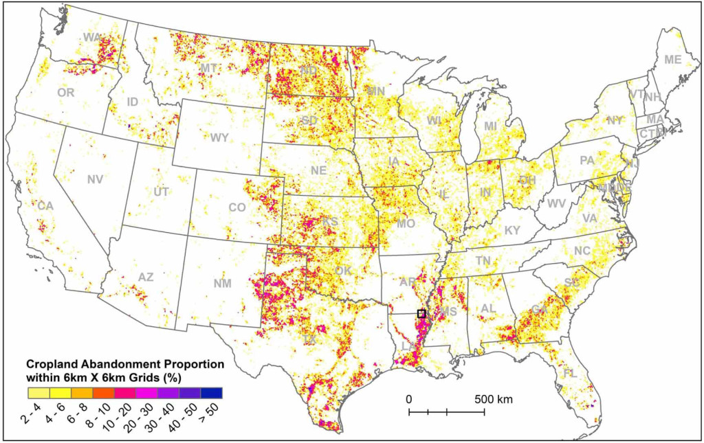
A map showing the percentage of abandoned farmland within a 36-square-kilometer area. Most of the more than 30 million acres of cultivated land abandoned between 1986 and 2018 is concentrated in the Great Plains and the Mississippi River valley.
Farmland is often a battleground in the fight against climate change.
Solar panels and energy crops are pitted against food production, while well-intended policy choices can create incentives for farmers to till up new lands, releasing even more heat-trapping gas into the atmosphere.
That’s why strategies for sustainable plant-based fuels focus on marginal lands — fields that are too hard to cultivate or don’t produce good enough yields to be considered profitable.
A new tool developed by scientists at the University of Wisconsin–Madison could help relieve that tension.
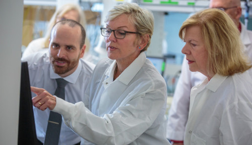
U.S. Energy Secretary Jennifer Granholm (middle) and U.S. Senator Tammy Baldwin (right) speak with Tyler Lark (left), scientist with the Great Lakes Bioenergy Research Center about an interactive tool for mapping abandoned farmland that could be used for energy production during a tour of the Wisconsin Energy Institute at UW–Madison on June 16, 2023.
Led by Yanhua Xie and Tyler Lark, researchers with the Great Lakes Bioenergy Research Center, the team used machine learning to map nearly 30 million acres of United States cropland abandoned since the 1980s, creating a tool that could guide decisions about how to balance production of energy and food.
Their findings, published in the journal Environmental Research Letters, include the most detailed mapping of previously cultivated land in the U.S. to date. They provide field-level resolution of abandoned farmland that could be used to grow crops like switchgrass or sorghum, which can trap carbon in the soil and serve as feedstocks for biofuels and replacements for petrochemicals.
“If we can understand where these lands are and what the characteristics are, we can really understand their true potential for things like climate mitigation,” says Lark, a scientist at UW–Madison’s Center for Sustainability and the Global Environment.
Lark, who studies land use change and its impacts on land and water resources, says that understanding could be used to direct clean energy investments where they have the least competition with other beneficial uses.
“That’s a key application of this,” Lark says. “Whether it’s for solar photovoltaic, or agrivoltaics, or cellulosic bioenergy development, or just restoration of natural ecosystems: These sites could be great candidates for a lot of those applications.”
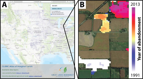
Screenshot of the GLBRC Atlas of Marginal Lands, which allows users to explore and download spatial datasets (A), and a zoomed-in example of the abandoned cropland dataset in a 1.5km2 section of southern Michigan (B). Field color in (B) indicates the earliest year in which land was no longer cultivated.
The study was a collaboration between researchers at UW–Madison and Michigan State University and was funded by the U.S. Department of Energy. The resulting data are publicly available in the GLBRC’s interactive atlas of U.S. cropland, which also maps trends in farmland expansion and irrigation.
Researchers have traditionally relied on datasets like the USDA’s Census of Agriculture, which provides county-level estimates of farmland at five-year intervals and can be used to estimate how much land has been taken out of production.
But until now there was no way of knowing exactly where that land was or when it was abandoned.
“Most of these estimates have all been at the county level,” Lark says. “This is really the highest resolution analysis available, looking right on the landscape — field by field, acre by acre — of where these crop lands are.”
While satellite imagery has been around for decades, without recent advances in cloud computing, Lark says it was impossible to classify the nearly 2 billion acres of land in the coterminous U.S.

Tyler Lark
To construct the team’s analyses, Xie, now a professor at the University of Oklahoma, used existing land cover data to train a computer to read those images and recognize patterns of cultivation. The researchers then had that algorithm analyze satellite data from 1986 through 2018 and categorize each pixel to determine whether it was cultivated.
The results accurately predict the precise location of abandoned croplands nine times out of 10 and can even pinpoint the year they were abandoned with about 65% accuracy.
The team found that more than 30 million acres of cropland were abandoned over those 32 years. Most abandoned land was concentrated in the Great Plains and along the Mississippi River between southern Illinois and the Gulf of Mexico.
Those 30 million acres don’t include urbanized land, which Lark says is unlikely to ever return to cultivation.
Of that abandoned cropland, more than half changed to pasture or grassland and about a third was either shrubland, forest, wetland, or bare.
Lark was surprised to discover that less than a fifth of abandoned land was enrolled in a formal conservation program, such as USDA’s Conservation Reserve Program, which pays farmers to take environmentally sensitive lands out of production. That means more land than previously thought could potentially be used to grow bioenergy crops.
“A lot of the assumptions were that this former cropland had a lot of overlap with formal conservation programs,” Lark says. “But we saw that they’re almost entirely distinct pools.”
Researchers can now use the resulting data to model how much biomass could be grown on these lands as well as their potential to trap carbon dioxide from the atmosphere in the soil.
The study does not explain why the lands were abandoned.
“The next step is to figure out the drivers,” Lark says.
To do that, Lark says the team may pull in other information like socioeconomic data and tax records to get a better sense of what’s happening at the parcel level — for instance, whether a farmer took one field out of production or sold the entire farm — and use that to identify potential uses for the land.
“If they’re farming a bunch of hay, that’s probably more easily adaptable to cellulosic biofuel feedstock, because they might already have the equipment … and you could harvest something like switchgrass then too,” Lark says. “If it’s somewhere where there’s no agricultural production at all anymore, it might be harder to do that, but maybe more suited for a solar installment.”
Tags: agriculture, sustainability
-
UW–Madison again named a ‘new Ivy’ by Forbes
The university was selected as one of the best in the country at "preparing and graduating the talent" that meets today's workforce needs.
-
UW–Madison graduate programs ranked among the nation’s best by U.S. News
Nearly 20 programs ranked in their respective Top 10 lists, shining a light on the breadth and depth of the university’s graduate offerings.
-
UW–Madison students ‘step into the professional world with a purpose’
More than 90% of UW graduates say their education prepared them for their career, according to new survey results.
-
How UW–Madison and industry are working together to shape Wisconsin’s AI future
As businesses explore how to apply AI effectively and responsibly, UW researchers, faculty and students are offering their knowledge in the emerging space.