
Students size up seismic sensor sites
University of Wisconsin–Madison students Matthew Kogle and Kelly Hoehn logged thousands of miles this summer driving rural Wisconsin roads, scanning the landscape. When they found a promising spot, they knocked on the door of the nearest farmhouse and tried to interest the owners in their cause.
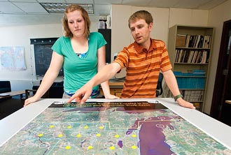
Graduate student Matthew Kogle (right) and recent graduate Kelly Hoehn (left) meet in Weeks Hall to discuss locations in southern Wisconsin that were visited as part of the USArray program. Kogle and Hoehn logged thousands of miles driving rural Wisconsin roads searching for appropriate locations and seeking permission from landowners to place the equipment on their property.
Photo: Bryce Richter
Door-to-door salespeople? Not quite. The geoscience students are recruiting Wisconsin landowners to become part of an exclusive group of about 1,600 people across the country to host a piece of a scientific grid that will span the country by 2014. The network of instruments, called the USArray, uses seismic waves to produce an image of the Earth’s internal structure — somewhat like taking a CT scan of North America.
“The main goal is to get an overview of what lies beneath the continental United States and eventually Alaska, using seismology to see inside the Earth,” says UW–Madison seismologist and geoscience professor Cliff Thurber, the local principal investigator of the USArray project. “What can we see and what does that tell us about how the North American continent evolved over time?”
The grid of 1,600 sites, each like a single pixel in a digital image, is part of the EarthScope project supported by the National Science Foundation. Four hundred sophisticated seismic stations started on the West Coast in 2004 and are creeping eastward across the country. Wisconsin’s sites are among the 200 that will be installed next spring and remain in place for two years.
Students like Hoehn, who just graduated with a double major in geoscience and geological engineering, and Kogle, a geophysics graduate student, are key to the USArray project and are responsible for selecting each of the sites. Two-person student teams are currently scouting from the Upper Peninsula of Michigan down to Louisiana.
The human element of finding people willing to host stations was a new angle for Hoehn and Kogle, but they’ve been pleasantly surprised with the responses.
“When we first started we were kind of nervous about how this was going to go. But I mean, this is Wisconsin, and people are just really nice,” laughs Hoehn, a Marshfield native. “It’s a really good experience getting out there and seeing Wisconsin.”
Guided by maps, they scan the area around each planned grid point for promising sites. They throw out urban areas as well as sites too close to roads, airports, train tracks or quarries, all of which make too much background vibration. Successful spots also have to have southern exposure (to power the solar panels) and good cellular phone service (to upload data to a central repository).
The landowners won’t be compensated for lending a bit of their land, but they are given a Web site where they can check seismic activity at their station 24 hours a day. “I tell them if they ever hear about [an earthquake] on the news to log in and see if it showed up” on their station, Kogle says.
“There probably won’t be many earthquakes in Wisconsin, but earthquakes happen all around us and the energy release propagates through the Earth, and this array picks it all up,” he says. The recent Canadian quake in southern Ontario was visible on EarthScope stations currently deployed in the Great Plains.
EarthScope also hopes to be an educational resource to participating landowners and their communities. Many station hosts have school-aged children who are curious about the stations and can use them for school projects, Hoehn says. The UW–Madison students can provide outreach materials from EarthScope that are appropriate for families or schools.
By the end of July, they will have selected 21 Wisconsin sites where seismic stations will be installed next year. Each station will have a buried vault the size of a large refrigerator, containing a high-quality seismograph and equipment to collect and transmit data. The stations are built into the ground to insulate the equipment against temperature changes and background noise.
The portable seismic stations are an evolution of instruments designed at UW–Madison by the late geophysics professor Robert Meyer and instrumentation innovator Lee Powell, says researcher William Unger, who is supervising the student team. “There’s a long history of this campus being involved in this type of seismology.”
The summer project has had an extra bonus for Kogle, who just moved to the Midwest last year. “I get to see a lot of Wisconsin by this grid system,” he says. “I’m finding really nice areas where I want to go check out the fall colors and where my next camping trip is going to be.”
-
Interwoven
How Indigenous knowledge and science can work together to communicate about climate.
-
UW–Madison’s reach throughout Wisconsin adds up to $38.9 billion a year
The university supports more than 287,000 jobs and helps drive private-sector growth.
-
‘Being part of something bigger than you’ with Badger Volunteers
UW–Madison students head into the local community to find purpose and make a difference.
-
UW–Madison’s Tech Exploration Lab: Where the classroom meets the real world
The lab is built around a simple expectation: Students come to build, test and refine projects with real problems in mind.


