
How ’bout that weather we’re having? A Q&A with Wisconsin’s State Climatologist.
The surface of Lake Mendota steams and begins to rapidly freeze as the air temperature plummets on Jan. 14. Photo by: Jeff Miller
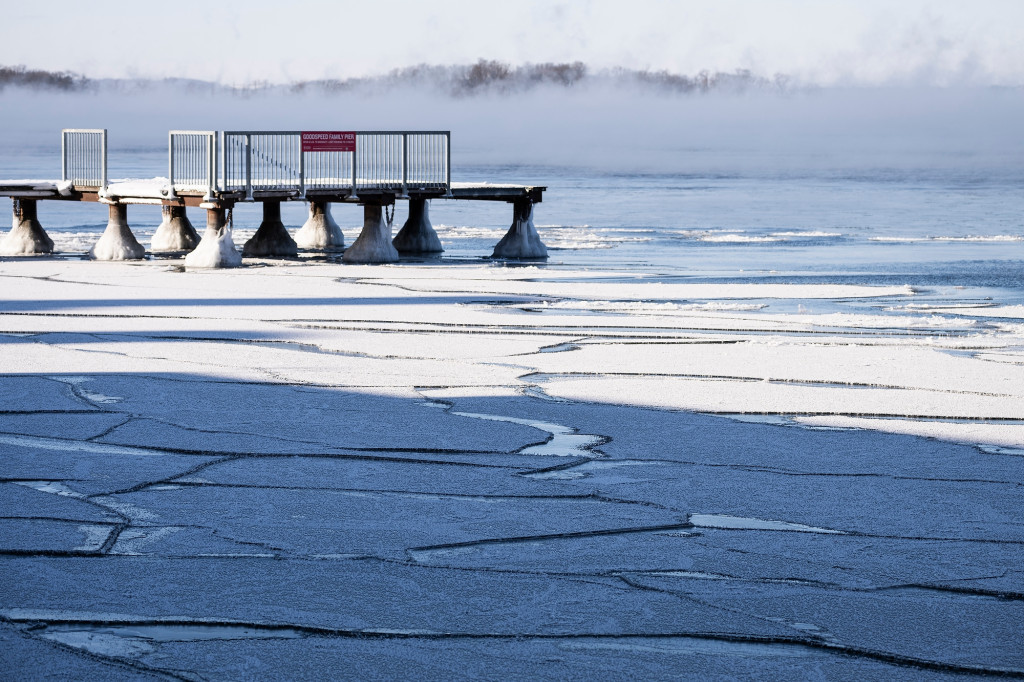
Looking southwest across Lake Mendota toward campus, the water’s surface steams and begins to rapidly freeze. Photo by: Jeff Miller
The ice starts to form on Jan. 14. Photo by: Jeff Miller
In a typical winter, temperatures fluctuate, snow falls (and melts) and cold snaps blast frigid air throughout the season.
But this year, the onset of cold temperatures, substantial snowfall and ice-over on some of Wisconsin’s most iconic lakes happened later than usual.
According to Steve Vavrus, the State Climatologist and a senior scientist at the University of Wisconsin–Madison’s Nelson Institute Center for Climatic Research, this December was Wisconsin’s warmest on record. In Madison, the capital city’s biggest lakes didn’t freeze until January 15th, making it one of the five latest ice-overs on Lake Mendota in 170 years of record-keeping.
To help put this winter into perspective, we spoke with Vavrus to learn more about what’s going on, and about what’s to come. The conversation has been edited for length and clarity.
Why was this winter so mild to start?
Lake Mendota’s open water is seen on Jan. 11, before it started to freeze. Photo: Jeff Miller
I think it’s a combination of a couple of things. One is the big El Niño event we have brewing in the Pacific [a period of warmer ocean surface temperatures in the Tropical Pacific that affects marine life, the jet stream and weather patterns]. Typically, when we get strong El Niños, the winters are milder than normal around here. In addition, we also have this long-term warming trend from climate change. It’s the two of them together that probably conspired to make for an exceptionally warm winter so far.
It’s actually getting harder to separate the El Niño effects from the climate change effects, especially because they favor the same kind of mild winter weather pattern. So, when we have a mild winter like this one, what’s the ultimate cause? It may be both. You don’t really know how much each is contributing.
What brought on the sudden spell of arctic temperatures we saw last week?
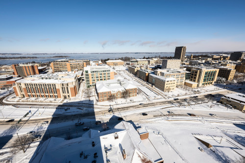
With air temperature plummeting below zero degrees Fahrenheit, a snow-covered University of Wisconsin–Madison central campus is pictured and the surface of Lake Mendota (on the horizon) steams. Photo: Jeff Miller
The arctic temperatures and conditions we saw last week are due to jet stream changes, I believe.
The idea is that the strength of the jet stream depends on the temperature difference between the Arctic and lower latitudes. When the jet stream winds are really strong, they bottle up the arctic air and keep it up north. But the Arctic is warming a lot faster than the rest of the world, which reduces the temperature difference between the Arctic and lower latitudes down to the equator, causing a weakened jet stream.
A weaker jet stream tends to meander more. If you get one of these weak, meandering jet streams it’s more likely that you’ll see cold polar air plunge down into mid latitudes.
But as often happens in science, there’s lots of other pieces to this puzzle and the climate system is very complicated. There are so many other factors that could drown that [jet stream hypothesis] out, El Niño being one of them. This Arctic linkage is probably just one of many that affect our winter climate in Wisconsin and elsewhere in the middle latitudes.
When temperatures did plummet, the lakes in Madison seemed to put on this beautiful smoke and fog show. What causes this?
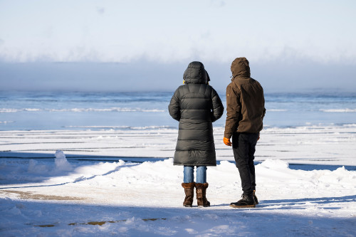
Two bundled people watch the surface of Lake Mendota steam and begin to rapidly freeze. Photo: Jeff Miller
The lakes were unusually warm for this time of year. I mean the fact that there wasn’t ice this time of year is unusual to begin with. And then we had this really cold air mass move over them.
So that meant there was an exceptionally big temperature contrast between the warm surface of the lake and the cold, overlying atmosphere. Warm air likes to rise since it’s lighter than the cold air. When that air rises enough, it condenses and you get this amazing fog show like you were describing, and it’s called steam fog.
It was fully expected, given the conditions. I was looking at the webcam for Mendota, and it was beautiful Sunday morning and Monday morning, the day the lake froze.
What definition is used to officially declare a lake frozen?
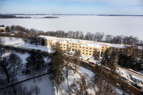
Lake Mendota, officially frozen, as seen from an upper floor of Van Hise Hall on Jan. 19. Photo: Jeff Miller
It depends on the lake. For lakes Wingra and Monona, and probably most lakes in Wisconsin, if it’s mostly covered in ice, most people would say it’s frozen.
But, Mendota, we have a specific definition. For whatever reason, the definition that’s been handed down over the years is there has to be frozen ice cover that would prevent a boat from getting across from the tip of Picnic Point over to either Maple Bluff or Governor’s Island.
So, if the State Climatology Office deems that a boat couldn’t cross, if the ice is too extensive or thick, we declare Mendota to be frozen over.
We try to be consistent with the definitions that were used years and years ago because it’s an amazingly long 170-year ice record and we want to maintain consistency.
Generally, our Assistant State Climatologist Ed Hopkins goes out with binoculars to different points around the lake, especially Observatory Hill, and observes and makes his best estimate. It’s probably how people did it 150 years ago. So that’s the old-fashioned way, but we continue to do that for consistency of data in the ice record.
Looking ahead at some of the warmer temperatures on their way, what might that do to all of the snowfall and lake ice that we’re now seeing?
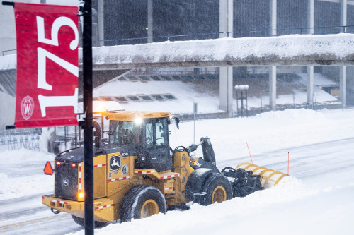
A heavy-duty tractor with a mounted snow plow clears a section of North Park Street passing through the heart of campus during a snowstorm on Jan. 14. Photo: Jeff Miller
I think it’s going to affect the snow more than the ice on the lakes. It is gonna get warm, probably well into the 30s next week. That’ll erode a lot of the snow and ice on the roads, and it’ll melt some of our snowpack, but the (lake) ice should be thick enough to withstand it.
Lake ice grows fastest when it’s thinnest. When it starts to first form, the ice is very thin, and that’s exactly when the ice is capable of growing quickly, as long as you have cold air temperatures. If you want to thicken ice quickly on a lake, you do not want to have snow cover on it. It would take a really pronounced warmup for quite a while to knock out the ice.
Tags: lake mendota, weather
-
Interwoven
How Indigenous knowledge and science can work together to communicate about climate.
-
UW–Madison’s reach throughout Wisconsin adds up to $38.9 billion a year
The university supports more than 287,000 jobs and helps drive private-sector growth.
-
‘Being part of something bigger than you’ with Badger Volunteers
UW–Madison students head into the local community to find purpose and make a difference.
-
UW–Madison’s Tech Exploration Lab: Where the classroom meets the real world
The lab is built around a simple expectation: Students come to build, test and refine projects with real problems in mind.


