
CSI Discovery: 3-D scanning researchers partner with Wisconsin law enforcement
On a chilly February 2014 evening in Mazomanie, Wisconsin, deputies from the Dane County Sheriff’s Office arrived at the scene of a homicide at an old, two-story house in a neighborhood blanketed with snow. Almost immediately, Deputy Sheriff Scott Lehman realized his team faced a monumental task in collecting and cataloging the evidence throughout the house.
At a crime scene, every detail has the potential to be significant, and it’s often not apparent which details matter until the later stages of an investigation. This particular house had a large number of rooms, each filled with furniture and other objects, all potentially important for the investigation.
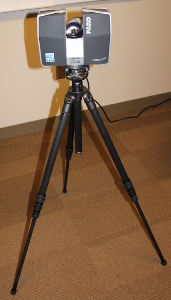
A LiDAR scanner uses a combination of lasers and a camera to create a 3-D model of an entire environment. The lunchbox-sized device sits on a tripod and slowly rotates 360 degrees.
Photo courtesy of Wisconsin Institute for Discovery
For help, Lehman called David Karls, a lieutenant in the sheriff’s office who had cultivated contacts with specialists in 3-D environment scanning systems. After a string of phone calls, Karls connected with Moehlman Bascom Professor Patricia Flatley Brennan of the Living Environments Laboratory (LEL) at the Wisconsin Institute for Discovery.
Brennan and the LEL team use 3-D environment-scanning technology to gain insights into how personal health information is managed in home environments. She enlisted the technical expertise of LEL programmer Ross Tredinnick, who prepared the lab’s LiDAR scanner and rode with Karls to the crime scene.
A LiDAR scanner uses a combination of lasers and a camera to create a 3-D model of an entire environment. The lunchbox-sized device sits on a tripod and slowly rotates 360 degrees. As it moves, an angled mirror rotates and reflects a laser into the room. The laser hits objects in the surrounding environment and bounces back. Through calculations based on the time it takes for the laser to return to the scanner, the system calculates millions of distance measurements. These measurements are tied to a panoramic photograph of the space to create a data set of full color 3-D points, often referred to as a point cloud. By combining point clouds from several locations, a full 3-D model can be rendered.
At the Mazomanie scene, Tredinnick completed 37 scans over the course of about 10 hours. Later, he stitched the scans together into a complete 3-D rendering of the crime scene, which he reviewed with Karls in the CAVE, a fully immersive, six-sided virtual reality environment located in the lower level at WID.
“To only capture a tenth of the information we gathered would have taken an entire 40-hour week, with two teams of two doing nothing but measuring and diagraming,” says Karls. Even then, the drawings and measurements would still only yield 2-D diagrams of the scene.
“To only capture a tenth of the information we gathered would have taken an entire 40-hour week, with two teams of two doing nothing but measuring and diagraming.”
David Karls
Increasingly, Karls says, 3-D scans are being used and accepted in court since they offer richer representations of a scene than diagrams and photographs alone. The scans also reduce the need for costly site visits during trials and minimize the risk of mistrials.
The 2014 Mazomanie case did not end up going to trial, since the defendant pled guilty and received a 20-year prison sentence. However, it marked the beginning of an ongoing collaboration between LEL and area law enforcement.
Currently, the lab and the sheriff’s office are pursuing a grant to expand the use of 3-D scanning, including a project aimed at building a library of bullet impact and trajectory patterns for various firearms. The team has also discussed pre-scanning high-risk public areas, such as schools and government buildings, to create detailed schematics for emergency situations.
In the meantime, the sheriff’s office has acquired a 3-D scanner, making the office the first law enforcement agency in the country to implement the handheld Panoscan PointGun scanner, which produces similar results to LiDAR.
“It was interesting for us to be able to apply our techniques and our work from other areas to something so tangible,” says Erica Gill, associate director of LEL. “It’s something we’re really proud of.”
—Nolan Lendved
Subscribe to Wisconsin Ideas
Want more stories of the Wisconsin Idea in action? Sign-up for our monthly e-newsletter highlighting how Badgers are taking their education and research beyond the boundaries of the classroom to improve lives.
-
Interwoven
How Indigenous knowledge and science can work together to communicate about climate.
-
UW–Madison’s reach throughout Wisconsin adds up to $38.9 billion a year
The university supports more than 287,000 jobs and helps drive private-sector growth.
-
‘Being part of something bigger than you’ with Badger Volunteers
UW–Madison students head into the local community to find purpose and make a difference.
-
UW–Madison’s Tech Exploration Lab: Where the classroom meets the real world
The lab is built around a simple expectation: Students come to build, test and refine projects with real problems in mind.


