Beyond the weather forecast: 5 ways UW satellite technology helps save lives
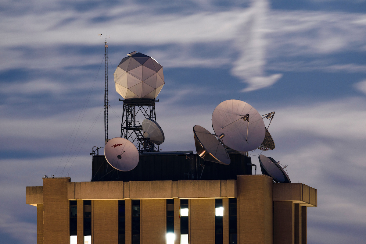
Satellite dishes and weather-related equipment mounted atop the Atmospheric, Oceanic and Space Sciences Building help UW researchers track the weather. Photo: Jeff Miller
Research at the University of Wisconsin–Madison drives innovation, saves lives, creates jobs, supports small businesses, and fuels the industries that keep America competitive and secure. It makes the U.S.—and Wisconsin—stronger. Federal funding for research is a high-return investment that’s worth fighting for. Learn more about the impact of UW–Madison’s federally funded research and how you can help.
The University of Wisconsin–Madison may be the birthplace of satellite meteorology, but scientists on campus have never stopped developing new ways for space-based instruments to protect and improve the lives of people back on Earth.
For more than 40 years, researchers at the Cooperative Institute for Meteorological Satellite Studies — a partnership between UW–Madison and the National Oceanic and Atmospheric Administration — have been working to turn satellite data into faster and more accurate weather forecasts.
While those predictions are useful when you’re wondering whether to carry an umbrella out of the house in the morning or which potato field may need irrigation over the next month, these UW–Madison researchers are also protecting you and your community in ways you may not expect.
“Technology is constantly advancing, improving our ability to observe our surroundings and enhancing our lives,” says Tristan L’Ecuyer, CIMSS director and a satellite researcher. “Our work at CIMSS is a great example. The innovative research we do here plays a critical role in delivering essential satellite products that support NOAA’s mission to improve public safety and well-being and effectively manage our nation’s resources.”
Here are just a few of the most recent ways NOAA’s support of CIMSS has made Americans safer and more secure:
1. AI-assisted hurricane prediction saves lives
When Hurricane Helene made landfall in Florida in September of 2024 as a furious, category-4 storm, it was preceded by estimates of wind strength and direction from AI tools developed by CIMSS scientists. Every bit of advance warning can spare the lives of people in the path of storms like Helene — as well as help protect their homes and businesses.
Used by the National Hurricane Center in Miami, the Joint Typhoon Warning Center, and other agencies worldwide, CIMSS algorithms add critical speed and accuracy to assessments of hurricanes that can abruptly grow stronger and shift their tracks. Applied to satellite data, AI-aided forecasts provide continuous coverage for areas where ground-based monitoring and data from reconnaissance flights are unavailable.
2. Dodging lightning and other severe weather
On June 19, 2024, severe weather formed over parts of New Mexico and Utah, resulting in storms and flash flooding from which several people needed to be rescued. A CIMSS-built tool called ProbSevere alerted National Weather Service forecasters to the developing storm two hours before dangerous conditions hit—warnings that gave residents invaluable time to take shelter.
ProbSevere employs AI to sharpen severe weather predictions using satellite data, shortening the wait for forecasts that protect people and their property from lightning, heavy rain, hail, winds and tornadoes. ProbSevere has been used to keep people safe during large events, including state fairs, festivals, concerts, NFL games and other sporting events, and large gatherings like national conventions.
3. Fighting wildfires faster
Just 10 minutes after smoke from what would be called the Dinosaur Fire was spotted near Boulder, Colorado, in 2024, the CIMSS-designed Next Generation Fire System detected the fire from space. Using data from a satellite orbiting Earth, the system helped pinpoint the fire’s location as the local fire department and emergency crews prepared to respond.
NGFS can provide highly accurate, real-time information on a wildfire’s location, movement, size and intensity, reports that help first responders and other emergency management agencies best deploy their firefighting resources and guide evacuations.
4. Following wildfires to protect against floods
Another 2024 wildfire, the South Fork Fire near Ruidoso, New Mexico, burned thousands of acres, destroying 1,400 homes and leaving a bare burn scar that greatly increased the risk of flash-flooding in the area.
The National Weather Service used a mapping tool developed at CIMSS to quickly identify burned areas and provide situational awareness of the changing conditions and flood risks. Combining data from nine different satellites, CIMSS scientists can provide maps of burn scars days and even weeks sooner than previous mapping methods. This greatly improves on our ability to identify flooding situations and potential debris flows that could otherwise compound the impact of one disaster with another.
5. Smoother and safer airplane flights
Millions of Americans fly across the United States every year, often sitting under a glowing seatbelt sign, heeding its message to mitigate the risk of dangerous turbulence. Researchers working on the CIMSS Turbulence Product are using AI to help aviation forecasters analyze satellite data in real time and help pilots avoid the atmospheric conditions that make flights uncomfortably bumpy — or worse.
This information is particularly important to flights over oceans, where measurements from weather balloons and ground-based sensors may be unavailable. The CIMSS Turbulence Product is now used by forecasters at the Aviation Weather Center, the Alaska Aviation Weather Unit, the Honolulu Forecast Office aviation weather desk and the National Weather Service’s Central Weather Services Units. It will soon be transitioned into operations at NOAA’s National Environmental Satellite, Data, and Information Service.
Tags: federal relations, research
-
Dancing for (over) a century
The Dance Department is preparing to celebrate the centennial of UW–Madison's (and the nation's) first dance major. Look back at some of the milestones that have shaped the program.
-
The Badger starter pack
From chamber music to the chemistry lab, these five UW intro courses see the highest enrollment — and set students up for long-term success.
-
How to win a Nobel Prize
Meet the UW–Madison faculty and alumni whose discoveries changed the world.
-
Teaching students to deliberate, not debate
In a public policy course, UW–Madison students put the science behind productive disagreement into practice.