
Tag Weather

‘Motion picture’ of past warming paves way for snapshots of future climate change
By accurately modeling Earth's last major global warming - and answering pressing questions about its causes - scientists led by University of Wisconsin–Madison and National Center for Atmospheric Research climatologists are unraveling the intricacies of the kind of abrupt climate shifts that may occur in the future.

Beating the radar: Getting a jump on storm prediction
Satellite observation of cloud temperatures may be able to accurately predict severe thunderstorms up to 45 minutes earlier than relying on traditional radar alone, say researchers at the University of Wisconsin–Madison Space Science and Engineering Center.

Hurricanes not likely to disrupt ocean carbon balance
Hurricanes are well known for the trail of damage and debris they can leave on land, but less known for the invisible trail left over the ocean by their gale-force winds - a trail of carbon dioxide.
Flood seminar seeks to avoid future devastation
Two national experts will join more than a dozen Wisconsin researchers and government officials in April in Madison at a symposium aimed at helping Wisconsin communities avoid devastating floods like those that inundated the Midwest last year.

Dust plays larger than expected role in determining Atlantic temperature
The recent warming trend in the Atlantic Ocean is largely due to reductions in airborne dust and volcanic emissions during the past 30 years, according to a new study.
City declares snow emergency
The city of Madison has declared a snow emergency. That means that alternate side parking restrictions will be in effect throughout the entire city of Madison, including the downtown/isthmus snow emergency zone.
Pioneer of climatology dies at 88
Reid Bryson, a towering figure in climatology and interdisciplinary studies of climate, people and the environment, and the founder of the University of Wisconsin–Madison's meteorology department and Center for Climatic Research, and the first director of the Institute for Environmental Studies, died in his sleep early June 11 at his home in Madison.
Curiosities: Why does the sky turn green before a tornado?
Scott Bachmeier, a research meteorologist at the Cooperative Institute for Meteorological Satellite Studies at UW–Madison, says that particles in the air scatter…

African dust forecast may help hurricane season predictions
As the official June 1 start of the Atlantic hurricane season approaches, forecasters are developing predictions about the severity of this year's season. For the first time this year, African dust may provide a piece of this puzzle.

The key to quieter Atlantic hurricane seasons may be blowing in the wind
Every year, storms over West Africa disturb millions of tons of dust and strong winds carry those particles into the skies over the Atlantic. According to a recent study led by University of Wisconsin–Madison atmospheric scientists, this dust from Africa directly affects ocean temperature, a key ingredient in Atlantic hurricane development.
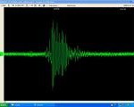
Photo, seismograph from Mendota ‘Ice Quake’ posted
The shaking felt Thursday afternoon in areas near Lake Mendota was most likely an ice quake, according to University of Wisconsin–Madison geologists. A tremor was recorded by a geology department seismometer at 12:50 p.m. Thursday, Jan. 31, 2008, and lasted approximately two or three seconds.

Curiosities: Is every snowflake unique?
One fact we know from childhood: every snowflake is unique. Isn’t it? UW–Madison’s snowflake…

UW space science technology powers Google Earth images
Satellite images provide a dramatic view of the Earth and its atmosphere. For timely views of winter weather in Wisconsin or wild fires in California, Google Earth users can now access the most recent high-quality satellite images generated at the Space Science and Engineering Center.
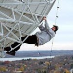
Recent sightings: I can see my house from here
Space Science and Engineering Center Space Science and Engineering Center student Jarek Sromovsky works to string holiday lights on a…

Recipe for a storm: The ingredients for more powerful Atlantic hurricanes
As the world warms, the interaction between the Atlantic Ocean and atmosphere may be the recipe for stronger, more frequent hurricanes.

Curiosities: What determines the colors of the sky at sunrise and sunset?
Photo: Jeff Miller The colors of the sunset result from a phenomenon called scattering, says Steven Ackerman,…

Jordan Gerth: Souping up state weather forecasts
Since arriving at UW–Madison from Kenosha in 2005 as a freshman, the atmospheric and oceanic sciences major has taken a lead role in a project that is making campus weather research tools available to frontline forecasters in Wisconsin’s National Weather Service (NWS) regional offices.
Curiosities: Why does the sky turn green before a tornado?
Scott Bachmeier, a research meteorologist at the Cooperative Institute for Meteorological Satellite Studies at UW–Madison, says that particles in the air scatter…
Weather advisory issued for this afternoon, evening
The National Weather Service is forecasting the possibility of severe and damaging storms during the course of Thursday (June 7) afternoon and evening. UW–Madison students, faculty and staff are urged to monitor rapidly changing weather conditions.