Model helps Wisconsin city planners prepare to weather large storms

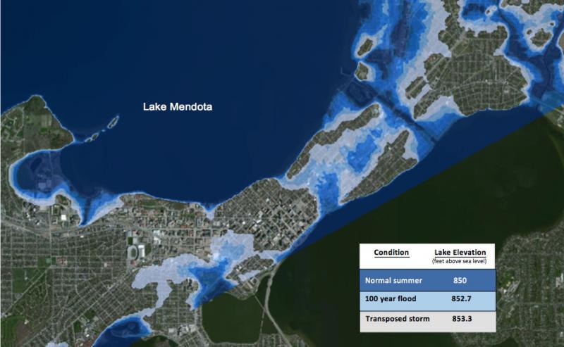
A projection of the Madison area’s vulnerabilities in an extreme rainfall event. Courtesy of the College of Engineering
Floodwaters from Lake Mendota and Lake Monona could reach clear across central Madison’s isthmus. If Lake Mendota breaks its banks, officials would be forced to close down Dane County Regional Airport.
How society should respond to climate change may be a global-scale debate, but University of Wisconsin–Madison researchers know that preparing for climate change’s impact on weather is a profoundly local problem.
Professor of Civil and Environmental Engineering Kenneth Potter and David S. Liebl, a UW–Madison faculty associate in Engineering Professional Development, are combining strengths in water resource management and outreach to help local communities better understand their vulnerabilities to large storms stoked by climate change. The two have developed a computer-modeling tool that essentially transposes rainfall data from a recent damaging storm in one area to a nearby area that might reasonably be expected to share the same weather and climate conditions.
In a prototype recently showcased in the National Oceanic and Atmospheric Administration U.S. Climate Resilience Toolkit, Potter and Liebl took the storm that caused the disastrous Baraboo River flood of 2008 and shifted it southeast to Madison. By computationally slamming heavy rains into the topography of Madison and the structure of the Yahara River Watershed, the model went beyond statistics to yield concrete predictions.
“It turns out that many people who influence public decisions are not very comfortable with statistically based predictions,” Potter says. “But a storm that occurred recently, where people witnessed a lot of damage, they know that could have happened 30 miles further south, so they tune in better.”
Potter and Liebl worked with professional engineers and officials at cities and counties around the state, along with state officials and scientists at the Wisconsin Department of Natural Resources. The ultimate goal is to build a computing tool that officials around the country could use to better plan infrastructure projects that account for storm predictions.
Potter says most statistical and modeling approaches to precipitation aren’t that useful to city- or county-level planners. Some global circulation models divide the entire state up into three grid areas, providing averages that would be a bit crude for, say, civil engineers plotting out worst-case storm scenarios in Dane County — and, just as importantly, such relatively crude data isn’t a great starting point for a conversation about climate readiness.
“Rainfall can be very local,” Potter says. “There are a lot of variables, and we felt that it would be difficult for decision makers to act on that kind of information.”
The key challenge, in both scientific and outreach terms, is to build something that will resonate on the local level for communities with varying needs, resources, weather patterns and geography. A truly flexible storm-prediction tool would require a database of transposable storms, and likely buy-in from federal agencies to develop computing tools that many cities and counties around the country couldn’t afford to develop themselves.
“We’ve used this 2008 Baraboo storm pretty effectively, but it’s limited in that it’s mostly going to be relevant to communities in the region and people who are aware of what happened in that storm, know the locality, know the Baraboo River and how it flooded the Interstate,” Liebl says. “Once you get further afield, you need to find storms that people can relate to elsewhere in the country. The character of storms and the type of rainfall we get here in the upper Midwest isn’t necessarily characteristic of other parts of the country.”
Even in Dane County, Potter says, the researchers want to refine their modeling by incorporating richer detail about the pathways water can take through the local landscape.
“Water can go through storm sewers connecting areas that from the topography you wouldn’t think are connected,” Potter says. “I’ve been working for a long time on statistical characterization of storms, and I’m convinced this is going to be a lot easier for people to understand and appreciate their vulnerability.”
Potter and Liebl’s research was funded by the NOAA Sectoral Applications Research Program and the Northeast Climate Science Center.
Enjoy this story?
Read more news from the College of EngineeringSubscribe to Wisconsin Ideas
Want more stories of the Wisconsin Idea in action? Sign-up for our monthly e-newsletter highlighting how Badgers are taking their education and research beyond the boundaries of the classroom to improve lives.
