
Geology professor drills into earth-shaking questions
Two months aboard an ocean-going ship might sound like a luxurious vacation.
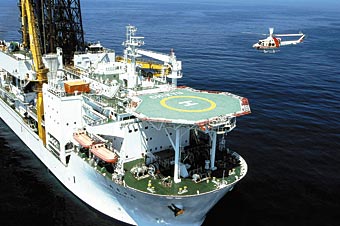
The Japanese drilling vessel Chikyu is equipped with advanced drilling technology capable of drilling boreholes into the ocean floor several miles deep. UW–Madison geologist Harold Tobin co-led an expedition to study deep oceanic earthquake faults and the geophysical processes that cause earthquakes and tsunamis off the coast of Japan.
Photo: courtesy JAMSTEC/IODP
With 16-hour workdays amid the clamorous hubbub of an industrial drilling rig, however, Harold Tobin’s recent voyage was far from relaxing. Tobin, an associate professor in the geology department, sailed last fall into the western Pacific in a quest to peer into the heart of one of the most active earthquake zones on the planet.
As co-chief scientist of an ambitious multiyear project in the Nankai Trough, an earthquake zone off the southern Japanese coast with a history of powerful temblors, he is working to unearth the geophysics of the deep-sea subduction zone faults responsible for some of the world’s most devastating earthquakes and tsunamis.
“The fundamental goal is to sample and monitor this major earthquake-generating zone in order to understand the basic mechanics of faulting,” Tobin says.
Accessing these faults to study them, however, is not a simple proposition. Subduction zone faults extend miles below the seafloor and the active earthquake-producing regions — the seismogenic zones — are buried deep in the Earth’s crust.
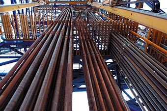
Sections of drill pipes are stacked on board the Chikyu in preparation for drilling deep boreholes into an active earthquake fault zone off the coast of Japan.
Despite intense interest in understanding how these faults work and what conditions may lead to quakes, their remoteness and inaccessibility have made direct scientific study virtually impossible, Tobin says.
He now has the opportunity to reach into the faults at last with the new Japanese drilling vessel Chikyu and the Nankai Trough Seismogenic Zone Experiment (NanTroSEIZE), an international collaboration overseen by the Integrated Ocean Drilling Program.
The Chikyu — “Earth” in Japanese — is equipped with the cutting-edge technology used to drill offshore oil and gas and is capable of drilling holes up to five miles into the seafloor.
“No one’s been able to make observations inside an active fault like this,” Tobin says. “The drilling is unique because it allows us access to where the earthquakes actually happen.”
Ultimately this project could yield an early warning system for earthquakes, but Tobin says they must first consider a more basic question: whether these earthquakes are even inherently predictable. Right now, “we don’t even understand the physics well enough to know the answer to that question,” he says.
Recipe for an earthquake
The strongest quakes on Earth — known as megathrust earthquakes — originate in subduction zones, areas where two of the massive plates that make up the Earth’s surface meet and slide across one another.
Subduction zone faults angle downward into the Earth as the lighter of the two plates rides upward and the heavier dives deep into the Earth’s mantle, where it will melt and cycle back to the surface as magma.
The two plates that meet in the Nankai Trough zip along in geological terms, advancing a few inches each year on average, Tobin says — about the rate your fingernails grow. At the boundary, however, tremendous friction between the plates locks them together. Pressure from the plate movements mounts until the system reaches a breaking point.
“Ultimately the strain builds up too much, and boom! It pops and slips forward,” Tobin explains. That accumulated energy can drive the upper plate forward 20, 40 or even 70 feet, he says, creating powerful seismic waves that make the crust shake and can produce a tsunami.
But many questions remain unanswered. What determines where the stress builds and where it dissipates harmlessly? What triggers a catastrophic release? Are there telltale signs of an impending slip?
“We’re collecting data in a very remote location,” Tobin says. “The ocean is harder to explore than space, in some ways … Even the basic topography of the sea bed is less well known than the surface of Mars.”
Out to sea
The NanTroSEIZE team embarked on the inaugural eight-week expedition with high hopes but many questions.
“Since we were the first operation on the ship, we went to sea not really knowing how it was all going to work,” says Tobin. “Of course there was an elaborate plan, but like all plans that you make before you’ve actually done something, they weren’t always germane to the situation at hand.”
For the first two weeks, the on-board scientists watched the drilling process with bated breath. “Were we going to have any success at all? Were we going to go home with our tails between our legs?” Tobin remembers wondering. “When we had actually drilled the first site … got some data out of it and things worked, we could all exhale.”
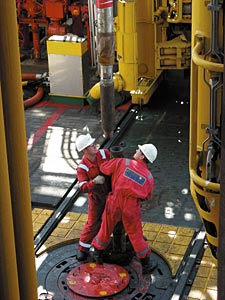
Drilling engineers work with a section of the powerful drill that is equipped with state-of-the-art technology and is capable of drilling boreholes into the ocean floor several miles deep.
It wasn’t all smooth sailing, as the technical demands of the project presented many challenges for the ship’s operators. The third week at sea brought problems with the ship’s dynamic positioning system, a GPS-based tool that can keep the nearly 700-foot-long ship locked within six feet of the same spot for days at a time — a critical ability when the ship is tenuously connected to the sea floor, several thousand feet below, by only the drill pipe.
Later, the team suffered a setback when the drill bit got stuck. The crew tried to retrieve it as the days ticked by with no progress. Amid their attempts to free it, the hole began to collapse and trapped the lower sections of pipe — including a section full of valuable data-logging instruments.
The loss of the instruments, though substantial, was not felt as keenly as the lost days slipping away. On a ship that costs roughly $200,000 each day to operate, Tobin says, “every minute of rig time counts.”
Tensions ran high as the scientists waited to find out if the expedition would continue. “We’re doing science that’s dependent on all this high-tech and heavy machinery working,” Tobin says. “When it doesn’t and it’s out of your hands, it’s frustrating.”
At last the problems were resolved and the crew ultimately successfully drilled four boreholes into the ocean floor near the fault zone, each thousands of feet deep.
“By the time we reached the end of the expedition and we really felt like we had accomplished something, it was fantastic,” he smiles.
Working in a bubble
The scientists did not have to wait until expedition’s end to take a crack at the first data, however.
With monitoring instruments embedded within the drill pipe, the team collected geophysical information about the rock layers while drilling through them, a process called logging-while-drilling.
The first data arrive at the ship nearly real-time, transmitted from the sea floor via “a totally cool technology called a ‘mud pulser’ which sends data bits up as little pressure waves in the column of water and mud that’s in the drill pipe,” Tobin explains. “There’s no way to run a wire up. It’s basically a modem that runs on mud.”
Other data are retrieved once the borehole is completed and the scientific team can begin initial analyses right on board.
The 19 scientists hailed from seven different countries, lending the work a multicultural flavor, while the focused work and close quarters created intense working conditions. Add the remote location and it’s a bit like working in a bubble, Tobin says. “The rest of the world starts to recede from your mind after awhile.”
As one of two chief scientists of the NanTroSEIZE project, Tobin was responsible for overseeing all the scientific teams on board and coordinating with the ship and drill crews.
The scientists make up a minority of the Chikyu’s 150-person capacity, while nearly 90 percent are dedicated to operating the ship, cooking, cleaning and running the drill round the clock. “A ship like this is just about as busy at 3 a.m. as it is at 3 p.m.,” Tobin says.
Typhoons and helicopters
Amid the trappings of a relatively normal lifestyle — work, eat, sleep, repeat — occasional events reminded the sea-faring party that they were not working in any ordinary research facility.
Deep-sea drilling in the Nankai Trough
UW-Madison geologist Harold Tobin describes the Nankai Trough deep-sea drilling project in this video produced by the Integrated Ocean Drilling Program.
This is a video story that requires the Flash 8 or higher player plugin. Download and install it.
The weather and environment required constant supervision and adjustments. Drilling could not proceed in high winds or ocean swells, and the approach of a typhoon necessitated a quick rerouting. Meanwhile, the location of the drill sites below the strong Kuroshio current — a Pacific equivalent of the Gulf Stream — taxed the ship’s dynamic positioning system.
Weekly lifeboat drills became part of the routine. With mainland Japan a 40-minute commute by helicopter, the entire crew was required to pass Helicopter Underwater Escape Training.
“They actually put you in a simulator and strap you in and turn you upside down in the water … There’s bubbles everywhere and you’re inhaling water up your nose,” Tobin describes. Though he successfully escaped from the contraption five times, “that was enough to convince me that if I was in a helicopter and it crashed in the ocean, I’d probably die,” he laughs.
Since Tobin returned to shore in mid-November, two more teams of scientists have headed to the Chikyu, still stationed over the Nankai Trough. UW–Madison geophysics graduate student Matt Knuth is aboard the third expedition, now in its final days, collecting rock cores to correlate with the drilling data from Tobin’s group.
Future NanTroSEIZE expeditions will collect more cores and extend the boreholes into the heart of the active fault zone, some more than three miles deep. Ultimately sensors will be installed in the boreholes to monitor physical stresses, movement, temperature and pressure.
From these instruments, rock samples and drilling data, the scientists hope to gain a full picture of the geophysical forces and changes leading up to fault movements and earthquakes.
“There may come a day … where we are measuring things that lead up to an earthquake and are able to issue an advance warning,” Tobin says. “But we’re a long way from that point.”
Tags: geology, international, research, video
-
Interwoven
How Indigenous knowledge and science can work together to communicate about climate.
-
UW–Madison’s reach throughout Wisconsin adds up to $38.9 billion a year
The university supports more than 287,000 jobs and helps drive private-sector growth.
-
‘Being part of something bigger than you’ with Badger Volunteers
UW–Madison students head into the local community to find purpose and make a difference.
-
UW–Madison’s Tech Exploration Lab: Where the classroom meets the real world
The lab is built around a simple expectation: Students come to build, test and refine projects with real problems in mind.


