40 years ago, UW researcher changed our view of the world
Forty years ago this month, thanks to an inventive University of Wisconsin–Madison scientist, our view of the world was changed forever.

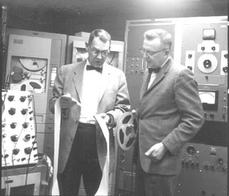
Bob Parent (left) and Vern Suomi (right) look at satellite data. The Space Science and Engineering Center was founded in 1965 by Suomi, a world-renowned meteorologist, and Parent, a professor in the College of Engineering. Together, they developed instruments to measure Earth’s heat budget from the first weather satellites.
On Dec. 6, 1966, a NASA Atlas rocket lofted the world’s first Earth-observing geostationary satellite into a 23,000-mile-high orbit, high enough to precisely match the spin of our planet on its axis and remain over a fixed point. On board was an innovative device known as the spin-scan camera, a gadget that made it possible to image the entire disk of the Earth and, for the first time, take pictures of the weather from space.
The 750-pound satellite, ATS-1 or Applications Technology Satellite, and its camera payload would revolutionize satellite meteorology, provide the first full-disk images of Earth from space, and lay the foundation for all of the satellite weather pictures that infuse our daily lives. It also provided the technology that made it possible to take the first pictures of Jupiter, Saturn and Venus from a spacecraft.
An invention of the late Wisconsin scientist Verner Suomi, the spin-scan camera “gave us the first pictures of the full disk of the Earth from space and would become a cornerstone of the remote sensing we take for granted today,” according to Hank Revercomb, who directs the UW–Madison Space Science and Engineering Center (SSEC), the center founded by Suomi and his collaborator, engineer Robert Parent.
“It was a milestone,” says Revercomb of launch of ATS-1 and its camera system. “It was up there before Apollo went to the moon, and it spawned a continual commitment to monitoring severe weather from space.”
The challenge in those earliest days of spaceflight, when there were no computer chips or modern electronics to do the heavy lifting for science, was to devise a way to take pictures from a “spinner,” a satellite that spun to create a stable platform in space.
“It is a challenge to take a picture from a spinning spacecraft,” Revercomb explains. “The spin-scan camera was a clever solution.”
The device worked by scanning the Earth as it spun, building an image a line at a time. With a line resolution of 3.2 kilometers, it took the camera 20 minutes to make a full picture of the Earth.
“What the camera did was look perpendicular to the spin axis, change its orientation slightly for each rotation of the satellite, and build up an image,” says Lawrence Sromovsky, an SSEC planetary scientist who worked with Suomi. “From that vantage point with that camera, you could see cloud patterns over half of the Earth. As Suomi said, ‘You could see the clouds move, not the satellite.'”
For meteorologists used to gathering data with high-altitude weather balloons and airplanes, the view from space changed everything, says Sromovsky.
Technology has long surpassed the spin-scan camera, but the legacy of Suomi’s simple invention is the pictures we see on the nightly news and on the Web of swirling storms and threatening weather systems.
“He (Suomi) was the first person to prove that there was value to looking at the Earth from space,” argues Sanjay Limaye, an SSEC planetary scientist, referencing Suomi’s earlier milestone experiment to measure the Earth’s radiation budget from space. “Prior to that, everybody was looking out, to astronomy. Nobody paid any attention to the fact we might learn something by looking at the Earth because there was no stable platform to do so.”
The same spin-scan technology was also used to take the first portraits from spacecraft of Jupiter, Saturn and Venus on the early Pioneer and Mariner missions to other planets in our solar system.
‘The Pioneer spacecraft, by design, were spinners,” notes Limaye. “There were no cameras you could put on a spinning spacecraft except for the spin-scan system.”
A later Earth-observing satellite, ATS-3, used spin-scan technology in 1967 to make the first full-color image of Earth from space, before the famous view of Earth taken by Apollo astronauts on the moon.
Suomi’s invention, which, fittingly, soared into space on the scientist’s birthday in 1966, has more than proven its value to the world, says Revercomb. “It’s paid off, certainly. It’s how we watch hurricanes and severe weather. It’s how we know storms are coming. Vern Suomi deserves his title as ‘father of satellite meteorology.'”


