
40-year map project, History of Cartography, draws to a close

Emily Hill, “Map of the United States” (1820). This large manuscript was the work of a schoolteacher in Vermont. From the entry in Volume 5 on “Education and Cartography” by Susan Schulten. Osher Map Library and Smith Center for Cartographic Education, University of Southern Maine
There’s nothing Matthew Edney enjoys talking about more than maps.
And, as director of the History of Cartography Project at the University of Wisconsin–Madison, his passion for maps and proclivity for painstaking research have made him the right person to steer to a successful conclusion the more than 40-year effort to produce a critical six-volume reference work of maps and map history.
The final volume — Volume 5, Cartography in the Nineteenth Century — will soon be completed thanks to $350,000 in funding from the National Endowment for the Humanities recently awarded to the project.

Matthew Edney
The History of Cartography series brings together cutting-edge research and a colorful collection of stories and histories told through maps. As a research, editorial and publishing venture, the project is drawing international attention to the history of maps and mapping. It treats all maps — from prehistory through the 20th century — as cultural, technical and intellectual artifacts.
With millions of words of rich content that includes extensive notes, plus thousands of illustrations, be forewarned: You don’t want to print it out on your home printer.
The project, published by The University of Chicago Press, comprises an interpretive encyclopedia of 409 entries written by 193 contributors. Volumes 1 through 4, as well as 6, have been completed and now the project team is focused on the final tome. The full series will eventually be made available in both print and digital forms.
Alongside Mary Sponberg Pedley, assistant curator of maps with the William L. Clements Library at the University of Michigan, Edney — who is also Osher professor in the History of Cartography at the University of Southern Maine — edited Volume 4, Cartography in the European Enlightenment.
The project began at UW–Madison in 1981 when its founding editors, the late David Woodward and J. B. Harley, envisioned an ambitious, multi-volume reference work that would examine the social and technical production and consumption of maps across cultures and in all eras. Woodward established the project, which ultimately expanded from a four-book series to six broadly inclusive and increasingly large volumes, totaling twelve actual tomes.
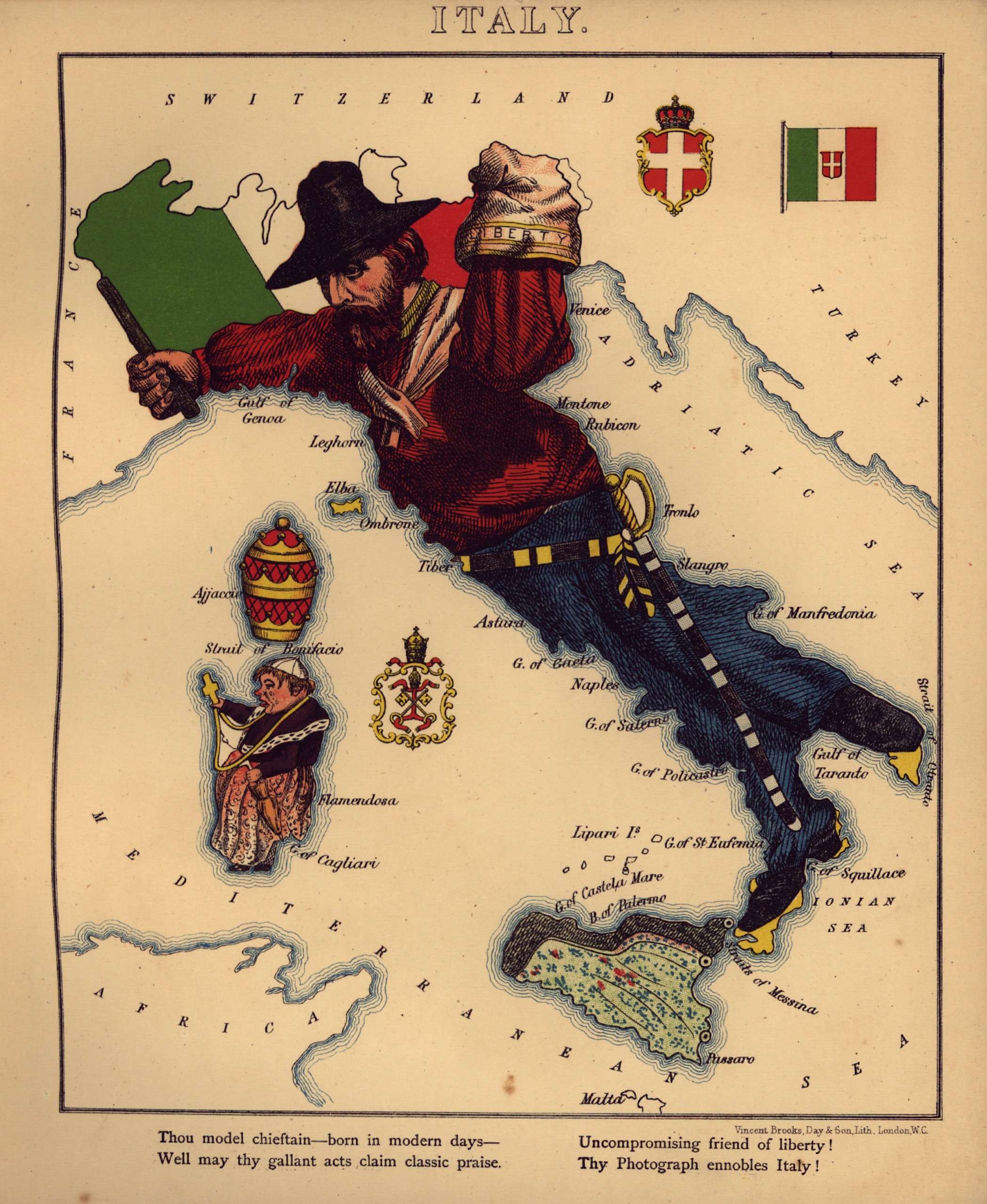
Aleph (William Harvey), “Italy,” in Geographical Fun (London: Hodder and Stoughton, 1868). One of a set of anthropomorphic maps of the countries of Europe, enhanced by the new technologies for color lithographic printing. From the entry in Volume 5 on “Education and Cartography” by Susan Schulten. Library of Congress, Geography and Maps Division
Volume 1, for example, was supposed to be 250,000 words, but when it appeared in 1987 it clocked in at 425,000 words. And as the number of volumes grew, so did the size of each volume.
“The volumes grew because there is all this really cool stuff,” says Edney. “David realized that if you are going to treat later periods with the same degree of detail and comprehensiveness, then the later volumes are going to become even larger as the number of maps increased with the rise of interest in the public sphere and rise of huge mobile armies instead of siege warfare and storming fortresses.”
He adds: “You had generals who were map nuts, like Napoleon. They needed maps to move the troops.”
Lithographic printing also exploded in the 19th century, making map reproduction easier and cheaper than ever. The project, too, has left its mark on the field.
“When Volume 1 — which was funded by the National Endowment for the Humanities — came out in 1987, it was absolutely revolutionary and it prompted so much new work in classical mapping and especially in medieval mapping,” says Edney, who first came to the project in 1983 as a graduate student before succeeding the founding directors in 2005. “The project makes you think about how someone — maybe the Romans, for example — thought about space.”
The project team considers accuracy and removing barriers to access to be among its major goals.
The online edition of the History (which includes Volumes 1, 2, 3 and 6) has received 4 million views since 2011. Chapters have also been translated into many languages. The project launched an online video series in spring 2021 to promote the recently published Volume 4.
Creating each million-word volume is a painstaking exercise that takes years of fact checking, translating, editing and image acquisition. It’s an effort that brings Edney back to the UW–Madison campus and Science Hall two or three times a year, in addition to frequent virtual meetings.
“We physically or digitally handle almost every work that we cite so that names, titles, journals, dates, places, publishers and pages are all correct. We carefully check all quotes,” Edney says.
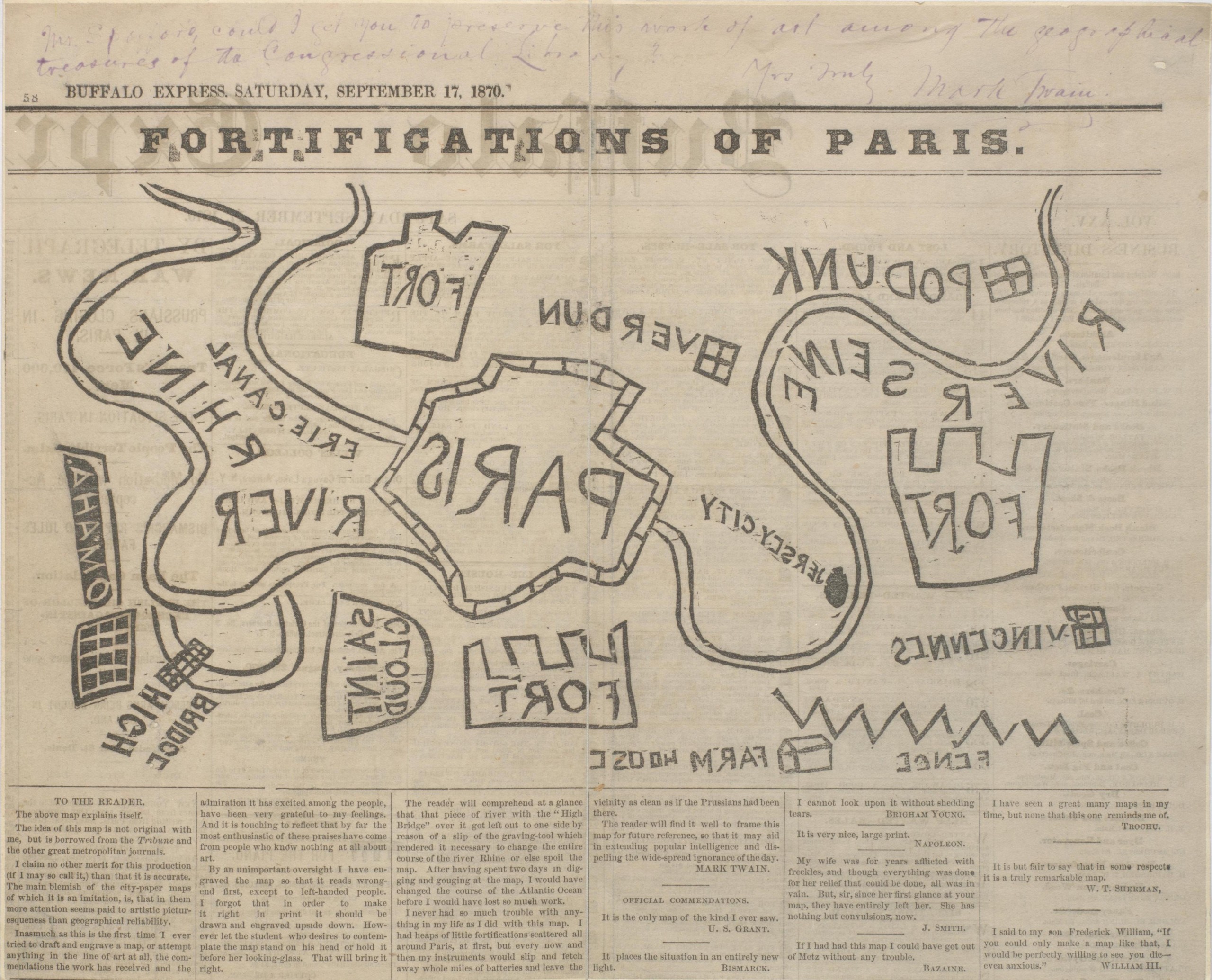
Mark Twain, “Fortifications of Paris,” Buffalo Express (Sept. 17, 1870). The one map that Mark Twain made himself, even cutting the wood block from which to print the map. He claimed not to know what he was doing, so cut the block right-reading and the map printed wrong-reading, increasing its absurdity. Library of Congress, Manuscripts Division
The process relies heavily on three skilled graduate student assistants who learn what it takes to produce multidisciplinary and collaborative research at a high level. These students have in recent years been funded primarily by the Office of the Vice Chancellor for Research and Graduate Education, with Wisconsin Alumni Research Foundation support, and by the College of Letters & Science.
Jude Leimer, managing editor of the project, holds a master’s degree in cartography from UW–Madison and has been involved since 1981. She trains the graduate students and runs the fact-checking process that makes the History so valuable as a research reference. She has overseen the editorial preparation and printing of every volume in the series and is an expert in the detailed processes necessary to maintain the History’s quality.
The project relies heavily on images, which can be expensive to reproduce.
“We want to show what it is that we are writing about and we set a ratio of one image to every 1,000 words,” Edney says. “We try to work with institutions that do not charge permission fees — most in the United States and some in Europe. We are treating the maps as cultural documents as much as statements of facts.”
Until 2007, when Volume 3 published, most of the images used in the project came from black and white glossy photos or transparencies. This made production even more expensive. But, by the 2000s, libraries were increasingly making their collections available online and the project has since been able to lean on digital resources.
“With Volumes 4, 5 and 6, we have received all but one image digitally,” Edney says.
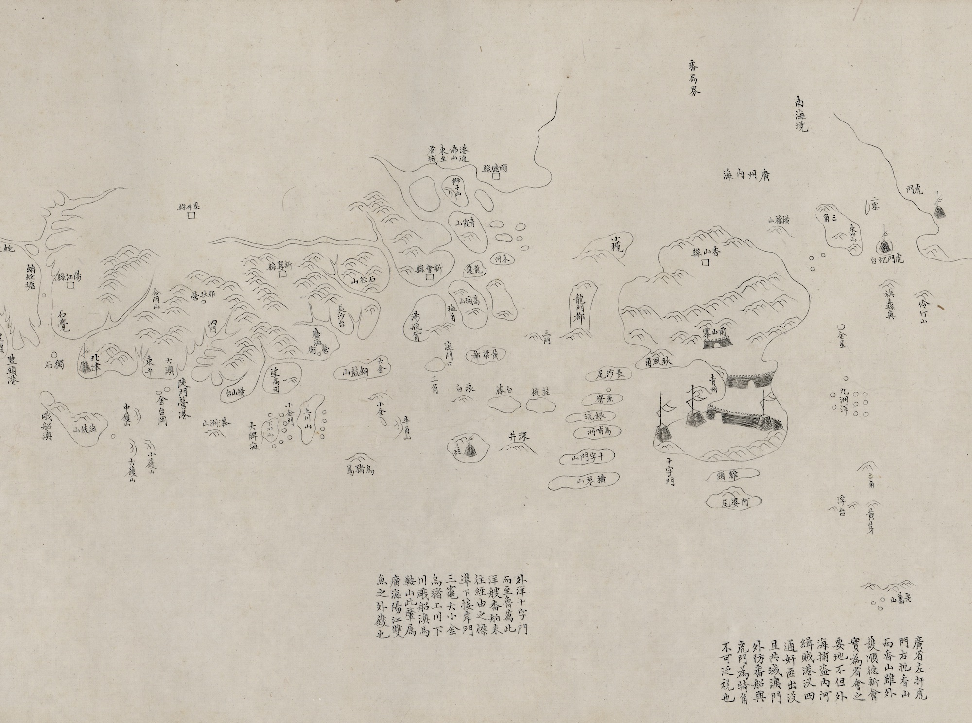
Detail of a coastal map of China (Guangxu, 1881). The entire manuscript scroll measures 13 inches by 306 inches. Library of Congress, Geography and Maps Division
Written content for each volume is contributed by experts in each particular area of map history. For some areas it can be a challenge to find an expert, especially in the later volumes that explore less studied areas of cartography, such as star charts, linguistic maps and journalistic cartography.
The project’s intended audience includes scholars, but Edney notes that entries have always been written for an educated but not necessarily specialized audience, including graduate and undergraduate students.
“Mary (Pedley) and I always asked ourselves: ‘Will this be understood by a high school student in Romania?’” Edney explains.
He hopes the final volume will appear in print in December 2027.
Across all the words and images contained within the project, one of Edney’s favorite chapters, on the Korean maps, can be found in Volume 2. It’s free to access online.
“It’s such a great, concise history of mapping in Korea and does a fantastic job of relating the mapping to cultural changes and developments in a way that explains Korean concepts nicely to non-Koreans and has been translated into Korean,” Edney says. “It sits on my bookshelf and is proof that the project is making an impact, internationally as well as nationally.”
Project fans and researchers can subscribe to the History of Cartography channel on YouTube and follow the project on Facebook.
The History of Cartography free online series:
Volume 1, Cartography in Prehistoric, Ancient, and Medieval Europe and the Mediterranean, eds. J. B. Harley and David Woodward (1987)
Volume 2, Book 1, Cartography in the Traditional Islamic and South Asian Societies, ed. J. B. Harley and David Woodward (1992)
Volume 2, Book 2, Cartography in the Traditional East and Southeast Asian Societies, ed. J. B. Harley and David Woodward (1994)
Volume 2, Book 3, Cartography in the Traditional African, American, Arctic, Australian, and Pacific Societies, ed. David Woodward and G. Malcolm Lewis (1998)
Volume 3, Cartography in the European Renaissance, ed. David Woodward (2007)
Volume 4, Cartography in the European Enlightenment, ed. Matthew Edney and Mary Pedley (2019)
Volume 5, Cartography in the Nineteenth Century, ed. Roger J. P. Kain (in preparation)
Volume 6, Cartography in the Twentieth Century, ed. Mark Monmonier (2015)
-
Interwoven
How Indigenous knowledge and science can work together to communicate about climate.
-
UW–Madison’s reach throughout Wisconsin adds up to $38.9 billion a year
The university supports more than 287,000 jobs and helps drive private-sector growth.
-
‘Being part of something bigger than you’ with Badger Volunteers
UW–Madison students head into the local community to find purpose and make a difference.
-
UW–Madison’s Tech Exploration Lab: Where the classroom meets the real world
The lab is built around a simple expectation: Students come to build, test and refine projects with real problems in mind.


