Director cultivates a mile-high appreciation of Wisconsin
From his 12th-floor office, Sam Batzli has a view of nearby Lake Mendota and Madison’s downtown punctuated by the state Capitol. But instead of looking out the window, Batzli looks at Madison and the rest of Wisconsin from much higher altitudes.
Batzli is the director of WisconsinView, a federally funded program that offers a free Web service for easy access to a variety of statewide images and data.“We basically provide a shortcut,” Batzli says. “WisconsinView offers free access to public domain data sets that would otherwise be difficult or expensive to acquire.”

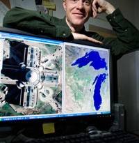
Sam Batzli, director of WisconsinView and an assistant scientist at the Space Science and Engineering Center, shows on his computer screen two examples of public-domain images available from the WisconsinView database. At left is an aerial photo at one-foot resolution of the Wisconsin State Capitol. At right is a MODIS satellite image at 250-meter resolution showing the state of Wisconsin. Photo: Jeff Miller
Taken by cameras and sensors aboard airplanes and satellites, images in the archive managed by Batzli help utility companies determine the best place for a power line or water main. Dairy farmers rely on information from Batzli to select good grazing pastures. Even Wisconsin’s weekend warriors rely on Batzli’s databases to assess hunting grounds and plan hiking expeditions.
“It’s crazy — you wouldn’t believe how many uses there are,” Batzli says. “These images help those who need more than just a coarse snapshot.”
Thanks to Batzli, anyone who wants a different look at Wisconsin can easily browse close to 2,000 gigabytes of perspective.
WisconsinView has nearly 5,000 registered users from around Wisconsin and beyond, with new users registering every day. Led by UW–Madison, WisconsinView is part of a nationwide effort called AmericaView. In addition to his role as the director of WisconsinView, Batzli also serves on the AmericaView Board of Directors.
The many types of information available through WisconsinView offer opportunities to query the land in different ways. Some investigate how the land is used, some check up on Wisconsin’s lakes and rivers, others want to know how an area fared in the latest tornado or severe weather outbreak.

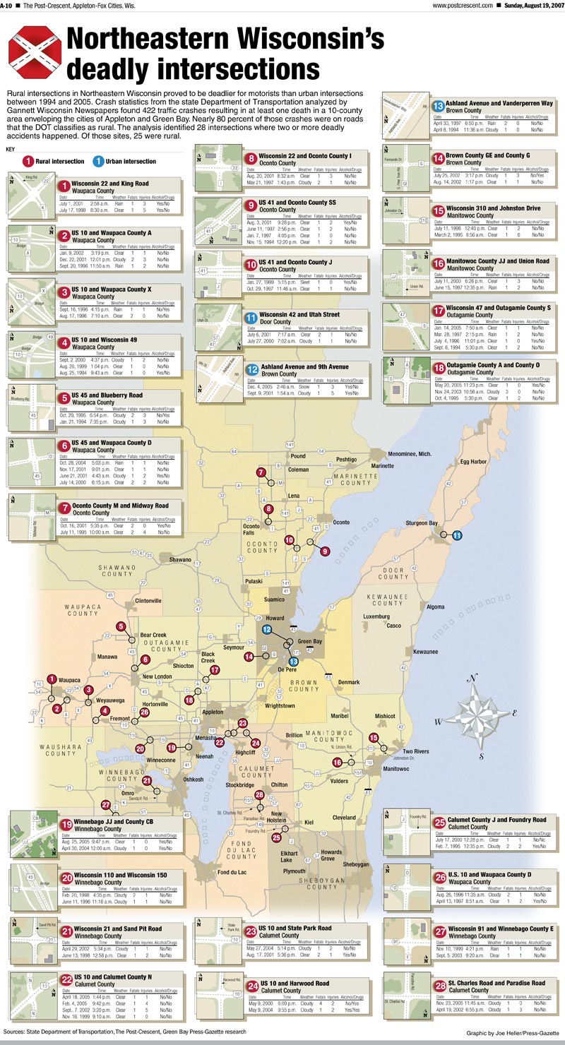
The Appleton Post–Crescent used WisconsinView to find images to illustrate a story about the deadliest intersections in northeastern Wisconsin.
Nick Spittlemeister, an analyst with Wisconsin’s Lake County Conservation District, relies on data from WisconsinView to map and analyze the use of environmentally protected land. “I use WisconsinView in just about every map we make,” Spittlemeister says. With the help of aerial photos from WisconsinView, Spittlemeister creates maps that show how the land has changed over the years. These maps help conservation teams assess how a property owner or developer has treated protected land.
Last summer, Wendy Harris, a reporter with the Appleton Post–Crescent, used WisconsinView to find images to create an illustration for a story that she wrote about the deadliest intersections in Wisconsin. Using WisconsinView, she found aerial photos of the specific intersections in her story. Harris imported the images into her mapping program and incorporated the data about the roads. The resulting graphic provided Post–Crescent readers with a good idea of which intersections to avoid. For a future story, she hopes to use aerial images of the Appleton area to map urban growth over the years.
According to Batzli, the collection of aerial photographs used by Spittlemeister and Harris is the most popular type of image available via WisconsinView. The U.S. Department of Agriculture sponsors aerial photography as a part of an effort to monitor farm fields around the country. These images help the government assess whether farmers have met the requirements to receive certain government subsidies.
You wouldn’t believe how many uses there are. These images help those who need more than just a coarse snapshot.
— Sam Batzli
Through WisconsinView, Batzli provides an easy way to find and download aerial photos of Wisconsin taken from 2004 through the present. Adjustments to the images account for terrain features and distortions caused by the camera angle, and allow users to put the images directly into mapping software. After selecting a location, users can download the images or image collections immediately.
The WisconsinView interface also provides free access to images from instruments aboard satellites that loop around the Earth from pole to pole. With his colleagues at UW–Madison’s Space Science and Engineering Center, Batzli develops and refines automated computer procedures that download the raw images from the satellites and convert those images into useful formats.
Batzli’s first task as a UW–Madison researcher was to use images from a NASA satellite known as Landsat to map the clarity of the 8,000 largest lakes in Wisconsin. He worked with data developed by colleagues who spent three years collecting and analyzing Landsat imagery. The scope of the project inspired Batzli to direct the development of a dynamic Web map supported by a database of spatial information.
In addition to the images used to assess the clarity of Wisconsin’s lakes, Batzli and his co–workers had accumulated a huge archive of remote sensing imagery stored primarily on CD–ROM. AmericaView offered a way to make that data available online. In 2003, Batzli and Tom Lillesand, a now–retired professor of forest ecology and management, pursued membership in the AmericaView consortium.
To establish Wisconsin as a member state, Batzli and Lillesand needed endorsements from remote sensing research and operational groups around the state. In 2004, UW–Madison took the leadership position and Wisconsin became a member of AmericaView, which currently includes 31 states and continues to grow.
Led by Batzli, WisconsinView has accrued many members including university, government and industry partners around the state. “WisconsinView is a nice umbrella for other land remote–sensing activities,” Batzli says. Members have helped expand the data archive by donating images purchased from federal groups that allow free redistribution of purchased data.
As the director, Batzli recruits new members and provides technical support and advice for WisconsinView members and users. “I basically bridge the gap between federal resources and those who need those resources,” Batzli says. With a background in museum work and historical geography, Batzli draws on a unique blend of cartography, geography and graphic design skills.
After graduating from UW–Madison in 1986, Batzli left the state to pursue a master’s degree in museum studies in Washington, D.C., where he developed exhibits at the Smithsonian and had an internship with the National Geographic Society. Batzli says that his museum experience helped him understand the importance of visual communication and inspired an interest in landscape photography and landscape change.
While working at Michigan State University, Batzli got involved in the NASA–sponsored Midwest Regional Earth Science Applications Center. UW–Madison was one of the partners in this project, allowing him to reconnect with the university through the Environmental Remote Sensing Center. When Batzli’s wife, Janet, accepted a position at UW–Madison in 2002, the center offered him a job.
Back in Madison, Batzli applies his experience and knowledge to environmental research and to helping people from all professions.
“Building a remote sensing network across the state has been really gratifying and has promoted the spread of local expertise,” Batzli says. “It’s also satisfying to know that I’m facilitating so many uses of these data through this online resource.”
Written by Jen O’Leary
Subscribe to Wisconsin Ideas
Want more stories of the Wisconsin Idea in action? Sign-up for our monthly e-newsletter highlighting how Badgers are taking their education and research beyond the boundaries of the classroom to improve lives.
Tags: The Wisconsin Idea


