
Birds-eye view of Wisconsin’s past wins governor’s award
A popular website that draws from tens of thousands of rare aerial photographs of Wisconsin will receive the 2011 Governor’s Award for Archival Innovation from the Wisconsin Historical Records Advisory Board.
The award was presented Oct. 7.
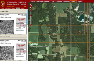
A screen capture from the WHAIFinder — the Wisconsin Historic Aerial Image Finder.
WHAIFinder — the Wisconsin Historic Aerial Image Finder, pronounced “wayfinder” — incorporated nearly 40,000 photographic prints taken by U.S. Department of Agriculture planes flying over Wisconsin from 1937-41.
“This is the oldest original aerial photo collection in the state,” says Jaime Stoltenberg, librarian in the Robinson Map Library at the University of Wisconsin–Madison. “It’s a very valuable resource to go back and see how the landscape has changed since the 1930s and ’40s. More visitors were coming to the library to use these photos than were coming for anything else in our collection.”
Begun in 2008 with an Ira and Ineva Reilly Baldwin Wisconsin Idea Endowment, the digitization process took the better part of three years. Now, WHAIFinder users can find sites around Wisconsin using current Google overhead views and with a click switch to the 70-year-old aerial photos or lay the historical images over the modern landscape for comparison.
The collection of photos — which falls just about 50 images short of covering the entire state — remain a well-used resource, often drawing more than 1,000 visitors per month, according to state cartographer Howard Veregin, who led the WHAIFinder project with Peter Gorman, head of the UW Digital Collections Center.
“Making the images available online increases by an order of magnitude their reach out into the community — especially the reach to the northern part of the state and places that aren’t within an easy drive of Madison,” Veregin says. “And digital preservation means the useful life of the actual photographic prints is extended.”
Environmental assessments, ecological research, genealogy and general curiosity draw people to the site. WHAIFinder is even used to settle property disputes.
“Surveyors use these photos to assist their efforts in recovering survey monuments, and determining the locations of abandoned railroads and other historic features,” Veregin says. “We’re serving a very broad cross-section of people from professionals to the general public.”
With a foundation laid for large-scale digitization projects, Stoltenberg hopes to add to WHAIFinder, should funding opportunities arise.
“We have newer collections of images covering just about every decade from the ’50s up through the mid-’90s, and the UW Digital Collections Center has farm plats, crop records, and other collections we could integrate with WHAIFinder that would be very useful to researchers,” she says. “And now that we’ve been through the process once, adding on should be relatively simple.”
Subscribe to Wisconsin Ideas
Want more stories of the Wisconsin Idea in action? Sign-up for our monthly e-newsletter highlighting how Badgers are taking their education and research beyond the boundaries of the classroom to improve lives.
Tags: The Wisconsin Idea
-
Interwoven
How Indigenous knowledge and science can work together to communicate about climate.
-
UW–Madison’s reach throughout Wisconsin adds up to $38.9 billion a year
The university supports more than 287,000 jobs and helps drive private-sector growth.
-
‘Being part of something bigger than you’ with Badger Volunteers
UW–Madison students head into the local community to find purpose and make a difference.
-
UW–Madison’s Tech Exploration Lab: Where the classroom meets the real world
The lab is built around a simple expectation: Students come to build, test and refine projects with real problems in mind.


