
Lake Mendota mapmaker shows depth of her appreciation
Caroline Rose remembers the first time she saw Lake Mendota. The Minnesota native had been accepted at UW–Madison and came to campus for a visit.
“It was this beautiful, sunny day,” Rose says. “There were sailboats out on the lake and it just looked so peaceful.”

Caroline Rose’s 3-D relief map of Lake Mendota was created using layers of magnetized composite board to depict the varying depths.
Like so many people, Rose developed a connection with the lake. Now, the student of cartography and geographic information systems, who is pursuing a master’s degree here, has paid tribute with a three-dimensional, magnetic map of Lake Mendota located in the renovated Hoofers space inside Memorial Union.
The planning started more than a year ago. Rose did much of the work at Sector67, a community workspace on the east side of Madison. There was plenty of trial and error, with Rose learning how to use equipment and testing materials that would best capture her vision.
“I was totally outside of my reach,” Rose says. “Now I feel like I’m much more prepared to tackle a project like this. They made it possible for me to do all of this, both with their help and their tools.”
The map was made to replace one at the Hoofers outdoor club and includes magnets to delineate notable sailing and scuba features in the lake.
Rose became a member of Hoofers in 2009 and has spent much time out on the water. She has long loved geography and nature. Creating the relief map combined both of those interests.

Rose sands the rough-cut edges of the map at Sector67 last December. “Cartography really is the intersection of art and science,” she says.
“Cartography really is the intersection of art and science,” Rose says.
Rose spoke with many different groups about what their needs were and how best they would use a map. She wanted it to be both useful and artistic.
The map functions as a teaching tool and encourages interaction. Removable magnetic labels allow Hoofer outing, sailing and scuba instructors to show important lake features and report events happening on and around the lake. As a student volunteer herself, Rose dedicated the project to the university students and community members who give their time at Hoofers.
She started by building a full-size model, cut out of single-ply cardboard using the Sector67 laser cutter. Modeling the piece helped her grasp the idea of the map as a full-sized object.
In the early planning stages, Rose had a lot of help from fellow Hoofer and experienced craftsman Dennis Mossholder, who suggested several of the materials ultimately used in the map, such as Baltic birch for the wood components.
Rose used data from the Wisconsin DNR to produce Mendota’s lake depth contours at 10 foot intervals.
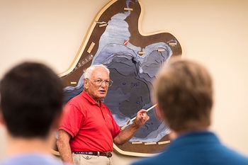
Instructor Joe Silverberg refers to Rose’s map of Lake Mendota while teaching a ground school sailing class.
After cutting out the map pieces, more table space and fewer power tools were needed, so the map moved to Memorial Union. Rose says that finding a suitable clear coat for the project was one of the greatest challenges. The finish had to hold up to touching and magnet movement, yet be thin enough not to impede magnetic attraction.
“The look of the enamel finish is great for this piece,” Rose says. “It gives the lake area a candy-apple shine and retains some of the texture of the brush-strokes, adding visual interest.”
The magnetic text labels were designed by a fellow cartographer and Hoofers member Eric Oberhart. Rose added some scuba diving flag magnets and hopes to create more.
While many in Madison are familiar with Lake Mendota, Rose hopes this map gives them a new perspective and appreciation.
“I think it’s just the familiarity. The lake is associated with so many good memories,” Rose says. “The more familiar you get with the lake, the more you develop a connection.”
Tags: arts, cartography, student life, water, Wisconsin Union